|
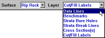
Data Lines |
The Data Lines layer contains the lines, points and labels. Data contained within this layer is used to generate the 3D surface.
|
|
Benchmarks
|
Contains any control points (Benchmarks) specified. These points are often used for re-scaling to plansheet or with AGTEK's Graphic Grade program.
|
|
Strata Bore Holes
|
Points used as boring to describe Strata layers as depths below the existing ground or by elevations that cannot exceed the existing ground.
|
|
Strata Break Lines
|
Break Lines area used to connect the bore holes which help the program determine the strata between the bore holes.
|
|
Cross Section(s)
|
Used to create profiles and cross sections across the job. This lines are also used to create stations and offsets.
|
|
Cut/Fill Labels
|
These are spots entered to be used in conjunction with the User Cut Fill Values located under the View Menu in Planview Mode. |